


The latest New Zealand Notices to Mariners, released on 12 December 2025, brings a handful of changes worth noting as we head into the heart of summer. While much of the technical detail sits in chart corrections and administrative updates, several items will affect everyday boating around the country. Here’s the wrap-up for recreational skippers.
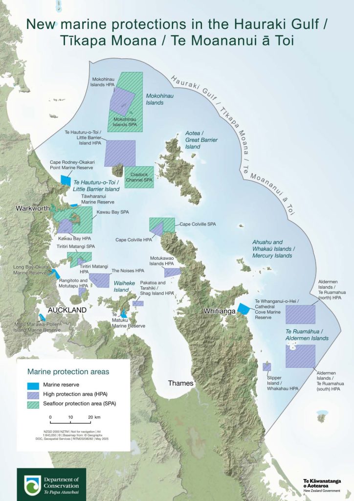
Major new marine protected areas in the Hauraki Gulf
The biggest development this month is the formal introduction of a wide network of marine reserves, high protection areas, and seafloor protection areas across the Hauraki Gulf. These stretch from Cape Rodney right through the Gulf and down toward the Aldermen Islands.
For boaties, this means new rules around anchoring, fishing, diving, and any activity that touches or disturbs the seabed. The zones are active now, so it’s important to check the latest DOC maps before you drop the pick or put a line over the side.

The aim is to rebuild fish stocks and restore some of the Gulf’s most pressured habitats, and these changes represent the most significant spatial protections introduced in many years.
Dredging and navigation updates at Whanganui
If you’re on the West Coast, be aware of ongoing dredging in Whanganui. Spoil grounds are active near Wharfs 1 and 2, and a temporary pile has been placed in the area. More importantly, the North Head Bar leading lights are currently unlit, which makes approaching the river mouth more challenging, especially in marginal weather or reduced visibility.
Take extra care on the bar, use multiple references for your approach, and keep an eye out for dredging vessels operating in the channel.
New edition chart for Gisborne
A new edition of NZ 5571 – Tūranganui-a-Kiwa / Poverty Bay and Approaches to Gisborne has been released. The previous version (from May 2025) has now been withdrawn. If you sail this coastline, it’s a straightforward upgrade to make sure your navigation gear matches the current chart.
Temporary buoys marking structures in Tasman Bay
Two temporary yellow buoys are marking submerged structures in Tasman Bay. They’re lit with a distinctive pattern — five yellow flashes every 20 seconds — and will stay in place until further notice. Anyone cruising or fishing this part of the Nelson–Tasman region should expect them and give the area a decent berth.

New sector light installed at Dunedin
A new U Shed Sector Light has been installed at Victoria Wharf in Dunedin. Its green, white and red sectors give a clearer alignment for vessels entering the area. For recreational skippers, this simply means approaches should feel a little more structured and easier to interpret at night.
A final reminder for the summer
Notices to Mariners always close with the same message and it’s worth repeating:
-
Carry the largest-scale chart available for the area you’re navigating.
-
Be aware that some parts of our coast remain only lightly surveyed.
-
If you strike an uncharted hazard, report it — the entire community benefits.
- Advertisement, article continues below -
With summer settling in and more boats on the water, now is a great time to update your charts, check the changes, and build these updates into your passage planning.


