HomeNewsEnvironmental & Sustainability NewsLittle Barrier Island no mooring detail

Little Barrier Island no mooring detail

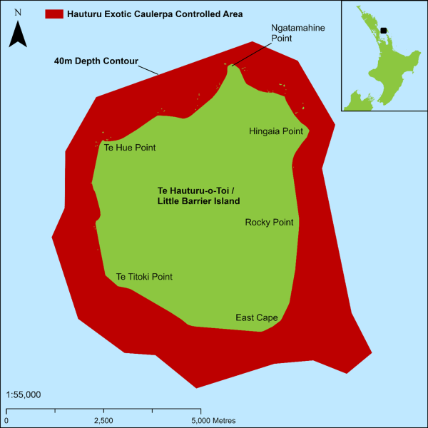
The controlled area surrounds the entire Hauturu Little Barrier Island coast, up to and including the high-tide mark and to a depth of 40 metres. Anchoring any vessel inside this controlled area is prohibited without a permit from Biosecurity New Zealand. Anchoring without a permit is allowed in the event of an emergency where no other alternative safe sheltering location or mooring can be easily found. This information comes directly from MPI - read it carefully as the penalties for breaking these rules are dramatic!

Written by

There are restrictions on some fishing activities within the controlled area that make contact with the seafloor (and can therefore spread exotic caulerpa). For example, you cannot use nets, dredging, bottom trawling, or cray potting. Fishing methods, such as line fishing from the shore or drift fishing from an un-anchored vessel are allowed. Spearfishing and hand-gathering are also allowed.

Before taking a vessel into or out of the controlled area, you must:

  • check the anchor, anchor chain and any equipment used in sea water (for example, fishing and dive gear) for attached seaweed
  • remove this plant matter and store it securely
  • dispose of it back on land so it can’t get back into the sea
  • clean all equipment thoroughly with fresh or salt water, and where possible, completely dry it before reusing in the ocean.
Share this
Olivia Christie doing baited underwater survey in Rangitoto and Motutapu HPA. DOC. // Photo credit: Credit Shelley Ogle.
Boat World

Marine scientists build snapshot view of Gulf’s ecosystems

Monitoring is underway across reefs and seafloor in the Hauraki Gulf/Tīkapa Moan...
Read more
Render of the new ProtectorE coming soon in partnership with Naut // Image supplied
Boating News

First ever electric ProtectorE coming soon in partnership with Naut

Rayglass and Naut have joined forces to develop the first fully electric Protect...
Read more
An image from Sentinel 2 provided through the Copernicus. // Supplied.
Boating News

Using satellites to monitor for coastal change

Earth Sciences NZ has been using new satellite data to track how coastal areas o...
Read more

Comments

This conversation is moderated by Boating New Zealand. Subscribe to view comments and join the conversation. Choose your plan →

This conversation is moderated by Boating New Zealand.

LEAVE A REPLY

Please enter your comment!
Please enter your name here

Chris Woodhams
Chris Woodhams
Adventurer. Explorer. Sailor. Web Editors of Boating NZ

Follow us

Recent articles