Warm, humid weather is on the way for early summer, with a chance of heavy rain for parts of the country.
In its latest Seasonal Climate Outlook, ESNZ says there is an 80 percent chance of La Niña conditions for November to January.
Forecasters predict warm and wet weather through to the end of 2025. Audio recording: RNZ Morning Report.
The stormy weather over the last two months is giving way to more settled conditions, followed by east to northeast winds from the tropics and subtropics.
Earth Sciences New Zealand (ESNZ) principal scientist Chris Brandolino told Morning Report that increased the odds for big rainfall events, particularly in the upper and eastern part of the North Island.
Brandalino said the second week of November was likely to bring another round of active weather coming from the west and northwest.
“It could bring some really heavy rain for parts of the country… We’ll see what that unfolds, but it’s going to be unusually warm. We’re probably going to get a period of pretty wet weather.
“Looking ahead to the next week or two, there’ll be a pretty big area of low pressure over the Tasman Sea, and that may put areas like the upper South Island and parts of the North Island under the gun for some heavy rain.”
Brandolino said there was still a lot of uncertainty as to what the weather will look like over the next few months, but some parts of the country, including the upper North Island, could see more rainfall, humidity, and increasing temperatures.
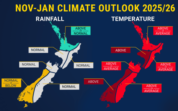
Bay of Plenty, Auckland, Northland, and Coromandel are likely to get wetter weather than usual.
There will also be more humidity, especially at night, particularly for the North Island.
Average or above-average temperatures were likely for all regions of New Zealand, except for the west of both islands, where above-average temperatures are most likely.
Rainfall was likely to be normal or below normal for the west of the South Island from November to January.
El Niño and La Niña are opposite phases of a global climate cycle that influence rainfall, temperature, and wind patterns all over the world. It’s an important factor in Aotearoa’s climate, though typically influences less than 25 percent of our seasonal patterns, ESNZ says.
During La Niña, ocean water from South America to the central Pacific gets cooler than usual thanks to extra-strong easterly winds churning deep-sea water up to the surface.
“With La Niña we tend to have more east to north east winds and when you get an air flow coming from the sub tropics to the tropics you’re going to get warm because air is coming from there but you’re also going to have that moisture and that does increase the odds for those big rainfall events particularly the upper to eastern part of the North Island,” Brandolino said.
On average, this means the country can see more north-easterly winds during La Niña that bring wet conditions to the North Island’s northeast, and drier conditions to the lower and western South Island.
ESNZ says soil moisture levels and river flows are forecast to be below normal for the east of the North Island, and near or below normal for the north of the North Island and east of the South Island.
“We haven’t pivoted quite yet we are in the process of making that motion if you will so there’s still going to be some lingering effects.”


