Finding a life raft or canoe adrift in the open Pacific is one of the toughest challenges in maritime search and rescue. Even with aircraft like the RNZAF’s P-8A Poseidon, vast distances, poor weather, and tiny visual targets can turn a mission into a needle-in-a-haystack exercise.
The SAR4SAR project – Synthetic Aperture Radar for Search and Rescue – aims to change that. The idea is deceptively simple: give a small vessel in distress a way to become highly visible to satellites. The execution, however, involves some clever Kiwi science, space technology, and a dose of old-fashioned practicality.
Instead of relying solely on emergency beacons or radios, SAR4SAR is developing lightweight radar reflectors that can be stored aboard almost any boat, deployed in seconds, and spotted from orbit. Once afloat, the device bounces radar signals from low Earth orbit satellites straight back to space, creating a bright signature on Synthetic Aperture Radar (SAR) imagery.
Because SAR works through cloud, darkness, and even wildfire smoke, it gives rescuers a 24/7, all-weather way to pinpoint a vessel’s position – potentially hours or days before a visual search would succeed.
From concept to real-world testing
The programme is led by New Zealand’s Defence Science & Technology (DST) group in partnership with the University of Auckland’s Space Institute and Institute of Marine Science.
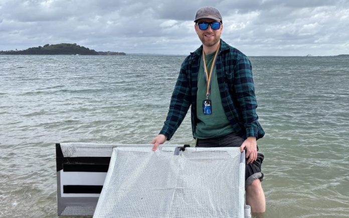
The first land-based trials in late 2024, at the university’s Ardmore field station, compared six off-the-shelf reflectors with two novel designs developed in-house. Over two to three weeks, satellites collected radar data to assess which reflectors returned the strongest, clearest signals. These results helped “de-risk” later sea trials by showing which shapes and materials worked best.
In February 2025, Phase 2A trials put five of the most promising designs to the test north of Omaha Beach. Deployed from the university’s research vessel Te Kaihopara, the reflectors were assessed for buoyancy, durability, and satellite visibility. Initial results were encouraging, with clear detections and valuable lessons for refining the design ahead of harsher testing.
Beating the elements in the sub-Antarctic
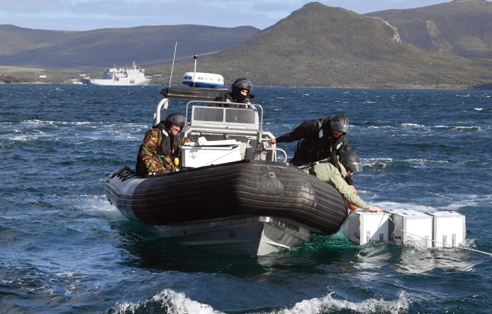
The real proving ground came during HMNZS Canterbury’s Operation Endurance voyage to New Zealand’s sub-Antarctic islands in March 2025.
Here, DST and University of Auckland scientists launched reflectors from Navy RHIBs in seas whipped by 50-knot winds. The devices popped open into three-dimensional shapes that stayed upright and intact despite the punishing conditions. Most importantly, they were tracked from space as distinct, bright points against the ocean surface.
That resilience in extreme weather is critical. As Dr Tom Dowling, one of the project leads, puts it: “We aim to make the needle so shiny that it can’t be missed.”
Low cost, high impact
One of SAR4SAR’s strengths is affordability. While modern emergency beacons and comms gear are excellent, they’re not always accessible – particularly in remote Pacific Island communities.
The project’s patented reflector design could be mass-produced for around $60. Made from everyday materials like aluminium foil, plastic sheeting, tarps, and gaffer tape, the geometry does the heavy lifting. Angled aluminium surfaces concentrate and reflect radar energy efficiently, producing a signature that’s unmistakable to trained AI analysis systems.
Dr David Galligan, Director of Defence Science and Technology, sees the humanitarian value clearly: “Many people in the Pacific go to sea with limited safety equipment. This could give them a much better chance of being found.”
The AI advantage
The SAR imagery collected from orbit is massive in scale. To make the system practical for time-critical rescues, SAR4SAR is integrating artificial intelligence tools to scan incoming radar data, detect potential distress signals, and pass accurate location cues to rescue coordinators.
This automation means fewer false alarms, faster response times, and better use of resources like long-range patrol aircraft, which are costly to operate and maintain.
Looking ahead
With Phase 2 trials now complete, the next steps will focus on refining shapes, sizes, and materials in sheltered coastal waters near Auckland during June and July 2025. These tests will prepare the reflector for Phase 3 trials, where operational realism will be the ultimate measure.
SAR4SAR isn’t designed to replace beacons or radios, but as a backup or low-cost alternative, it could be a game-changer – particularly in New Zealand’s massive 30-million-square-kilometre search and rescue zone.
For now, the combination of Kiwi innovation, cutting-edge satellite tech, and AI-driven intelligence is bringing that goal into sharper focus. If the project delivers as hoped, the next time a fisherman, sailor, or paddler vanishes beyond the horizon, their odds of coming home will be much better.
Further reading
Detecting small vessels in distress using SAR systems (2 October 2024) https://www.dst.mil.nz/news/detecting-small-vessels-in-distress-using-sar-systems
Research to help New Zealand search and rescue efforts (24 February 2025) https://www.dst.mil.nz/news/research-to-help-nz-search-and-rescue-efforts
SAR4SAR testing moves to the Sub-Antarctic (28 March 2025) https://www.dst.mil.nz/news/sar4sar-testing-moves-to-the-sub-antarctic
Low-cost lifesaving device for sea rescues (14 August 2025) https://www.dst.mil.nz/news/sar4sar-collaboration-proving-successful


