


A number of other watches and warnings are in place across the country in what MetService is calling an “impactful” weather event.
MetService meteorologist John Law said the heaviest rainfall was expected from Northland to Bay of Plenty and its intensity and duration would bring “threat to life from dangerous river conditions, significant flooding, and slips”.
“A red warning signifies that people need to act now as immediate action is required to protect people, animals and property from the impact of the weather. People should also be prepared to follow the advice of official authorities and emergency services,” he said in a statement.

How’s the weather looking at your place? Email us at iwitness@rnz.co.nz
It was the third red level warning MetService had issued this year.
Conditions would disrupt travel, make some roads impassable, and isolate communities, it said.
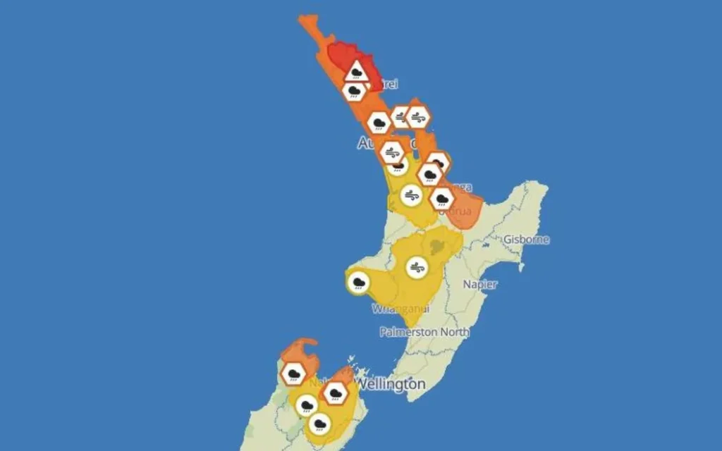
The remainder of Northland is under an orange level rain warning with 150mm to 250mm of rain forecast over the same period.
MetService said there was a high chance this will be upgraded to a red level warning.

Thunderstorms are possible in the area on Thursday afternoon, it said.
MetService said the escalation to a red warning came as a deep area of low pressure from the sub-tropics approached New Zealand.
“In addition to the heavy rain, this is likely to be a multi-hazard event spanning several days with heavy rain, strong winds and large waves also expected.”
Orange level heavy rain warnings are also in place for Great Barrier Island, Auckland from Whangaparaoa northwards and Coromandel Peninsula from the early hours of Thursday morning and into Friday.
In Bay of Plenty, west of Whakatāne, an orange warning is also in place with up to 250mm of rain forecast from 9am on Thursday until 3am on Saturday.


Orange level strong wind warnings are in place for Northland from 9pm Wednesday until 11pm on Thursday and for Auckland and Great Barrier Island from 8am Thursday until 1am Friday with 120km/h gusts forecast.
🚩 Red Rain Warning issued for Northland 🚩
Significant rainfall is expected for Northland over the next two days with 270-320 mm of rain expected for eastern areas. There is the potential for downpours from training bands of very heavy rain from Thursday afternoon. pic.twitter.com/9VRVMQNN1K
— MetService NZ (@MetService) March 24, 2026
In the South Island, orange level heavy rain warnings are in place for Tasman west of Motueka from 10am Thursday to midday Friday and Richmond and the Bryant Ranges from 6pm Thursday to midday Friday.
Meteorologist Silvia Martino said the impacts might not be seen right away.
“This will be a long event, it carries on for a couple of days, so while we might not get to warning amounts [today], we are expecting over time that rain to build up to warning levels.”
Earlier on Wednesday, she explained forecasters would be working with local authorities to determine if a red warning was needed.
“The decision about whether to go to a red warning is one that’s made based on what the impacts are likely to be.
“What our expert forecasters will be doing is talking to the council, talking to people on the ground about what the impacts are expected to be from the amount of rain we’re forecasting, and then together they’ll make the decision about whether a red warning is appropriate.
“With the heavy rain, we’re looking out for the risk of surface flooding, of possibly areas being cut off, and reminding people to avoid floodwaters. If you can avoid travel then that’s for the best.”
Clear the gutters, put anything away that could be a source of danger from wind, Martino said.


