


From his boat at Mercury Cove on the Coromandel, Chris Newman had a good night. Sheltering on advice from the New Zealand sailing crew, he reported no trouble through the storm, the sea inside the cove staying surprisingly flat despite an easterly running at 25 knots gusting 30. The barometer was sitting at 1005 hectopascals and still dropping as he checked in, with the eye of the storm expected to pass through late morning and bring a brief break in conditions. It was a composed and matter-of-fact report from someone who had picked his spot well.
The picture elsewhere was rougher. RNZ reported gusts of up to 130 kilometres per hour in the outer Hauraki Gulf and around Coromandel overnight, trees coming down on power lines and more than 600 homes losing power in the Coromandel Forest Park area between Te Kouma and Te Mata. PowerCo’s outage map listed landslip as the cause of some individual outages.
Northland copped it harder. The entire region is under a state of emergency, with gusts reaching 120km/h at Cape Reinga and Tutukaka Harbour overnight. More than 100mm of rain fell across parts of Northland in 24 hours, the Whangarei CBD recording 122.5mm. Around 1,000 homes lost power between Waimamaku and Whirinaki in the Far North, though some have since been reconnected. Six households in central Kerikeri were evacuated over concerns about a stand of redwood trees nearby.

Three state highways remain closed. SH2 through Waioweka Gorge, SH1 through Mangamuka Gorge and SH35 between Te Araroa and Hicks Bay were all shut as a precaution. Emergency Management Minister Mark Mitchell urged people off the roads and out of the weather, with a direct warning to act on instinct rather than wait for official alerts. “If you see flood waters rising or suspect that a landslide is about to occur, get away immediately.”
Fire and Emergency responded to twelve incidents overnight, none life-threatening, most involving fallen trees and roofs lifting in the wind. Rescue teams remain on standby in Whangarei, Auckland, Rotorua, Tairawhiti and Coromandel.
Tauranga is the main concern through today. Civil Defence has flagged a potential threat to life around this afternoon’s 2.30pm high tide, when the centre of the cyclone is expected to sit directly over the city. Coastal and low-lying residents have been urged to self-evacuate now, with centres open at Whakamarama Hall, Baypark and Matua Bowling Club.
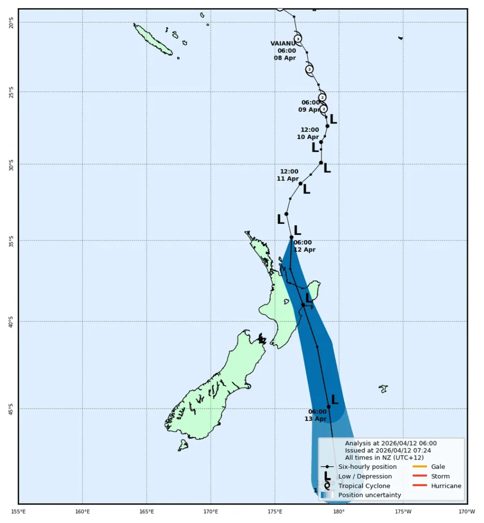 Current map of Cyclone Vaianu’s path from MetService. Photo credit: MetService
As of 7.46am the centre of Vaianu was 160km northeast of Great Barrier Island, still tracking southeast. MetService warnings for Northland remain in place, with a review scheduled around 10am. The rain has largely stopped in the Far North but continues in Whangarei and Kaipara.

The morning has gone better than many feared. What the afternoon brings around Tauranga is another question.
This report is written by Boating NZ but also contains information and reporting from RNZ.co.nz who are the statutory civil defence lifeline radio broadcaster.


