Key points for boaters:
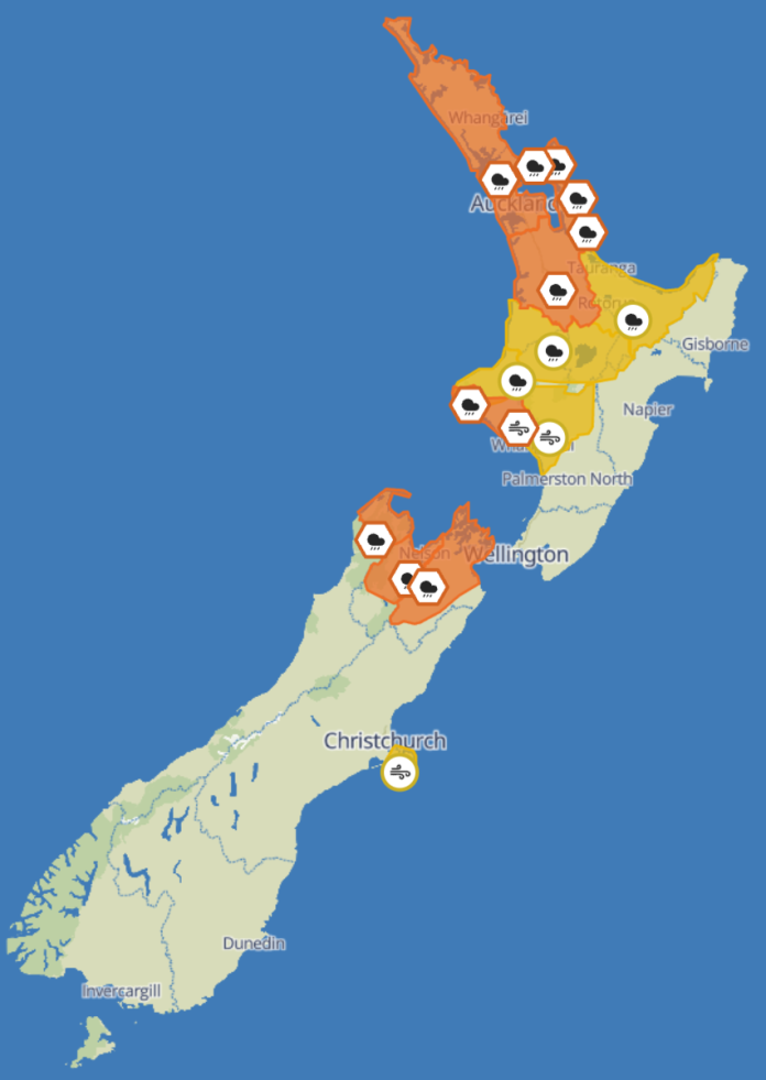
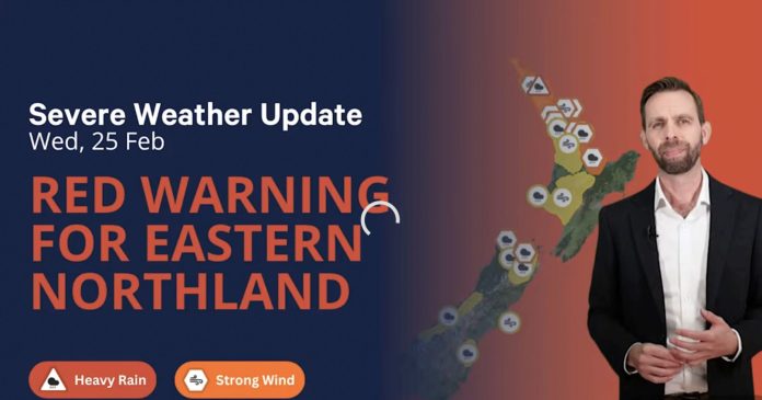
- Heavy Rain Warnings (Orange) issued for Auckland, Northland, Coromandel, Waikato, Taranaki Maunga, Tasman, Nelson and Marlborough
- Strong Wind Warning (Orange) for southern Taranaki with gusts up to 120km/h
- Watches in place for Bay of Plenty, Rotorua, Waitomo, Taupō, and Taihape, with upgrades possible
- Highest rain totals of 150mm forecast for Taranaki Maunga and northwest Tasman
- Conditions hazardous for moored vessels, coastal ramps, river bars, and road trailers
- MetService advises boaters to check forecasts often and take pre-emptive action
- Weather begins easing Saturday, but saturated catchments may prolong impact
Incoming front to lash marine zones
A strong northerly system is tracking across New Zealand, bringing with it heavy rain, gales and coastal disruption. The front arrives in full force on Friday 11 July, moving eastwards across the North Island and upper South Island through Saturday morning. MetService has issued a broad swathe of Heavy Rain and Wind Warnings, many of which directly impact marine and boating regions.
Coastal boaties, liveaboards, and trailer boat owners are advised to secure vessels and avoid non-essential movement during the system’s peak. River bars, estuaries, and exposed anchorages are expected to become highly unstable by Friday afternoon.
“This is one of those systems where marine users from the Far North to the Marlborough Sounds need to keep a close watch on updates,” says MetService. “Heavy downpours, gusty winds, and rising catchments will all play a role.”
Northland and Auckland: Orange Heavy Rain Warning
- Timeframe: 6am to 10pm Friday
- Rainfall forecast: 80 to 100mm, with peak rates of 20 to 30mm/h expected in the afternoon
Boating impact:
- Risk of flash flooding around estuaries and harbours
- Launch ramps and marina access roads may experience surface flooding
- Mooring lines should be checked and doubled where possible
- Visibility at sea likely to be reduced by downpours
Great Barrier Island, Coromandel Peninsula, Waikato: Orange Heavy Rain Warning
- Timeframe: 11am Friday to 2am Saturday
- Rainfall forecast: 90 to 110mm, with intense rainfall in the evening
Boating impact:
- Rising streams may affect anchorage in river-fed inlets
- Slips likely along coastal roads and trailer routes
- Check stormwater systems aboard vessels and avoid isolated beaches
Taranaki Maunga: Orange Heavy Rain Warning
- Timeframe: 11am to midnight Friday
- Rainfall forecast: 120 to 150mm, with 30mm/h peaks
Boating impact:
- Potential for flooding at the Waiwhakaiho and Oakura River mouths
- Road closures may affect access to coast ramps
- High rainfall will trigger runoff into the Tasman Sea, causing silty, confused seas near river bars
Tasman (northwest of Motueka): Orange Heavy Rain Warning
- Timeframe: 9am to 9pm Friday
- Rainfall forecast: 120 to 150mm
Boating impact:
- Major runoff expected into Golden Bay and rivers west of Motueka
- Slips likely on roads into marinas and boat sheds
- Anchorage in inlets should be re-evaluated ahead of peak rainfall
Nelson and Tasman (southeast of Motueka to Lake Rotoroa): Orange Heavy Rain Warning
- Timeframe: 9am Friday to 1am Saturday
- Rainfall forecast: 80 to 100mm
- Notes: High chance of upgrade to Red Warning
Boating impact:
- Sounds boaties should expect surge conditions and dangerous anchorages
- Floodwaters may back up around jetties, moorings, and tidal flats
- Slips and road washouts possible on SH6 and regional roads
Marlborough (northwest of Awatere Valley): Orange Heavy Rain Warning
Timeframe: 9am Friday to 1am Saturday
Rainfall forecast: 80 to 100mm
Boating impact:
- Sounds entrances and Pelorus-Kenepuru inlets likely to experience runoff surge
- Potential for slips affecting Portage and Havelock access routes
- Trailer boats should delay transit where possible
South Taranaki: Orange Strong Wind Warning
- Timeframe: Noon to 11pm Friday
- Wind forecast: Severe gale northeasterlies gusting to 120km/h
Boating impact:
- Mooring loads and swing circles must be re-checked
- Canvas, biminis, and clears should be secured or removed
- High-sided boats on trailers at risk of wind roll or shifting
Areas under Watch: Be alert for upgrades
Bay of Plenty (including Rotorua):
- 1pm Friday to 5am Saturday
- Heavy Rain Watch in place, with 20–30mm/h peaks possible
Waitomo, Taupō, Taumarunui:
- 2pm Friday to 2am Saturday
- Moderate to high chance of upgrade to Orange Warning
Taranaki north of Opunake:
- 11am to midnight Friday
- Currently under Watch, but heavy bursts could meet warning thresholds
Taihape and Whanganui:
- Strong Wind Watch from noon to midnight Friday
- Northeasterlies may reach severe gale
Banks Peninsula:
- 6pm Friday to 4am Saturday
- Winds may approach severe gale in exposed locations
Advice for boaties
If you’re planning to head out before the system hits, or even sit through it aboard, preparation is key. Here’s what experienced skippers are doing:
- Checking mooring lines, snubbers and fenders for wear and shock absorption
- Inspecting bilge pumps and batteries, ensuring power reserves in case of outages
- Avoiding launching until post-storm surge and floodwaters have cleared
- Clearing drains, freeing scuppers, and making sure anchor wells aren’t clogged
- Delaying trailer transit where forecasted road flooding may trap tow vehicles
- “This is not a weekend to take chances with a dodgy anchor setup,” said one Sounds-based launch owner. “We’ve seen boats drift into mooring fields before after a rain front like this.”
Inland effects still felt by boaters
Even for inland regions under Watch, such as Taupō, Rotorua, and the Central Plateau, these weather conditions will affect those storing or towing vessels. Surface flooding on roads, treefall risk, and saturated launch ramps may delay plans well into Saturday.
The weather clears slowly Saturday
While the main system is expected to pass early Saturday, residual showers, strong gusts, and runoff surges will persist. Catchments will be heavily loaded, meaning any additional rain could still cause localised flooding through Saturday night.
Final word: check twice, launch later
This system is widespread, fast-moving, and multi-faceted. Boaties across the upper half of New Zealand should remain alert and flexible. Whether you’re moored in the Hauraki Gulf, heading out from Whanganui, or hauling a trailer near Nelson, treat this as a serious marine weather event.
Check the marine forecast, tidy your lines, and delay your trip. Let the storm pass before you return to sea.


