


What is driving the change
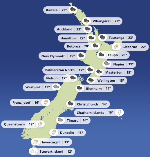
A low in the Tasman Sea is pushing towards central New Zealand today. A warm front has stalled over central districts, and a cold front is moving in from the west. The whole system slides east on Friday. A ridge of high pressure arrives from the southwest on Saturday, bringing a cooler southerly flow. A larger high sits over the South Island on Sunday and extends over the North Island on Monday.
Puysegur: gale warning and very rough seas
The sharpest conditions are in the far south. Puysegur carries a Gale Warning today. Southeast winds are 20 knots at first, rising to 35 knots north of Puysegur Point this morning. Seas build to very rough. A long period southwest swell is about three metres, easing later.
On Friday, southeast winds sit near 25 knots, but southerlies rise to 35 knots north of West Cape in the morning. Sea state remains very rough in the north. These are hard conditions for any small craft, and uncomfortable in larger boats.
Upper North Island: Hauraki Gulf, Coromandel, and Bream Head to Colville
A Strong Wind Advisory is in place for Bream Head to Cape Colville, the Hauraki Gulf, and Coromandel. Northerlies build from 15 knots this morning to 20 knots gusting 30 knots, then 25 knots gusting 35 knots later today. Winds turn northwest this evening. Seas become rough for a time in the afternoon and evening.
Showers are expected, with poor visibility at times. Thunderstorms are possible from morning in the Hauraki Gulf and Bream Head to Colville sector, and later in the day around Coromandel.
By Friday, winds ease back. Bream Head to Colville trends northwest 20 knots, easing to light variable in the morning and becoming southwest later. In the Hauraki Gulf, northwest 20 knots turns southwest 10 knots in the morning as showers clear. Coromandel sits near northerly 20 knots before shifting northeast then westerly, with showers clearing.
Hawke Bay: afternoon blow, then easing
Hawke Bay is also under a Strong Wind Advisory. Winds start light, then northeast 20 knots develops late morning and rises to 25 knots gusting 35 knots for a time this afternoon. It turns northerly 20 knots gusting 30 knots, then eases to 15 knots in the evening. Seas become rough for a time. Showers bring poor visibility, and thunderstorms are possible, mainly in the afternoon. Southerly swell is about one metre and stays near that on Friday as winds swing easterly then southerly.
Looking ahead through the weekend
Friday stays unsettled, with showers in the North Island easing later, while the South Island sees rain in the east with heavy falls before easing. Saturday improves for most areas as the ridge arrives. Sunday looks broadly settled under high pressure, though parts of the North Island may still see cloud and scattered showers in the east and north.

Chatham Islands remain more active, with periods of rain that may be heavy and thundery, easing to showers Friday night and clearing early Sunday. Strong northerlies turn to strong southerlies on Saturday afternoon, easing Sunday.
On the water: If you are heading out today or tomorrow, plan for squalls in showers, sudden gusts near the front, and a quick lift in sea state in open water. If in doubt, stay local, shorten the trip, or wait for the high to settle things down.


