


Despite its modest size, between the 15th and 17th centuries Portugal was one of Europe’s richest nations. The wealth stemmed from its overwhelming maritime dominance which led to the discovery of new, very lucrative, global trade routes. But on a fateful day in 1755 everything collapsed – literally.
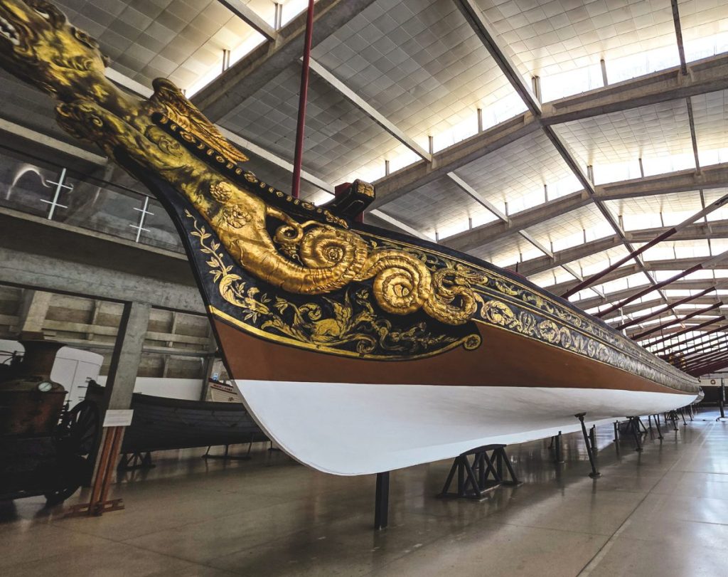
wealth is reflected in the Royal Barge – now lying in the city’s wonderful Maritime Museum. Pity the 80 oarsmen. // Photo credit: LAWRENCE SCHÄFFLER
Historians refer to the 15th – 17th centuries as the Age of Discovery – a period in which Europe enjoyed major advances in science, technology, astronomy and cartography. Largely driven by trade.
Portugal sat at the forefront of the expanding knowledge base – thanks to its extraordinary maritime expertise. It pioneered developments in shipbuilding, navigation, exploration, and mapmaking. All because of a thirst for exploring what lay beyond the horizon – and any riches (spices, gold, and silver) that might be found there.
Ultimately, this small nation of adventurous sailors opened the world by discovering new routes and charting previously unknown territories – the coasts of Africa, Asia, and the Americas – in the process establishing a global empire. How did such a small country become the ruler of the waves?
A combination of technology, science, and vision. Because it was something of an outlier perched on the western edge of the Iberian Peninsula, Portugal was perfectly positioned to explore new business opportunities by looking south and west, especially as Europe’s economy was in the doldrums: the continent was still reeling from the catastrophic 14th century bubonic plague.
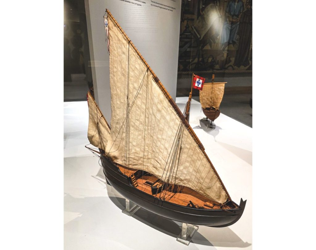
Fortuitously, Portugal’s innovative maritime sector was way ahead of its time. It had developed the caravel, a small (typically 18m-20m), shallow-draught ship with a lateen rig. It carried a stern-mounted rudder (replacing the oar-steering common on many of the period’s vessels). Compared with a traditional square-sail ship, these gave the caravel high manoeuvrability and superior windward ability. Perfect for sniffing around uncharted coastlines.
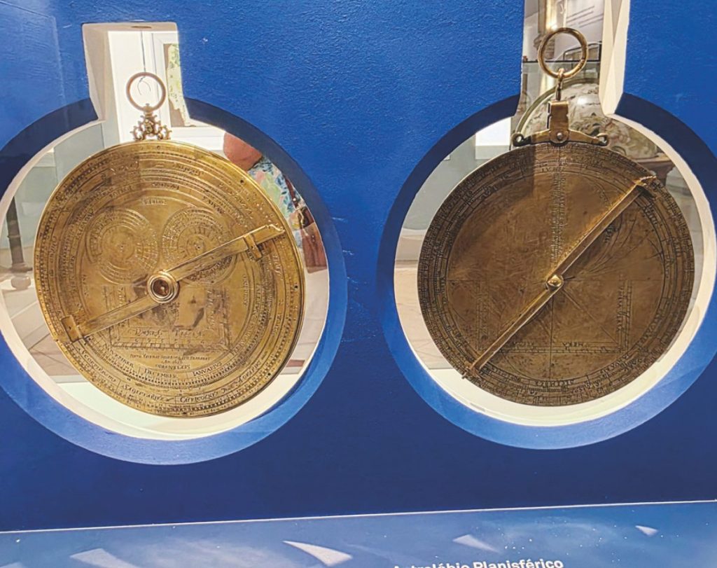
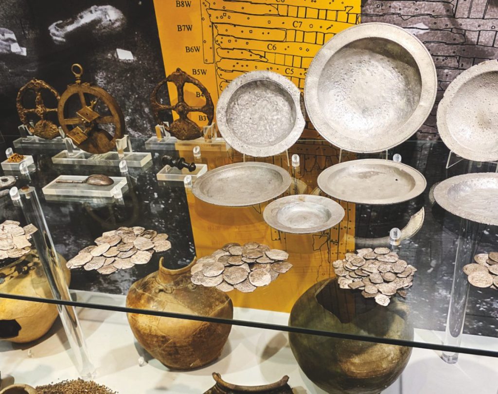
In addition, a sophisticated cadre of Portuguese mathematicians, astronomers, and cartographers advanced navigation enormously – fine-tuning instruments such as the astrolabe. This allowed them to chart new territories accurately. Portuguese sailors were expert star navigators and easily transported their skills across the Equator. One of the new constellations they found proved a reliable constant – the Southern Cross.
A few key personalities underpinned the advances: Prince Henry the Navigator (though not an explorer himself) controlled the maritime purse strings and sponsored the expeditions. A devout man, he wanted to spread Christianity, but his main objective was finding a sea route to the East – and filling Portugal’s ships with exotic spices. Cinnamon, ginger, black pepper, saffron, nutmeg, and others.

Scores of gutsy explorers helped the cause, among them Bartolomeu Dias and Vasco da Gama. Having charted the west coast of Africa, Dias completed the first voyage around the southern tip of Africa in 1488. Da Gama followed 10 years later, skippering a fleet all the way to India.
Over the next few centuries Portugal established ports around Africa and Asia – places like Ormuz, Malacca, Kochi, the Maluku Islands, Macau and Nagasaki. It dominated the Asia-Europe trade route and much of the trade within Asia. The colonial empire swelled – as did its coffers.
The expeditions also stumbled upon a less attractive but very profitable opportunity: the African slave trade. In addition to being traded, the unfortunate Africans served as labourers for the establishment/tending of Portuguese sugar plantations – another lucrative commodity.
Dividing the spoils
Inevitably, rival nations were swept up in Portugal’s slipstream – mainly Spain, but also England, the Netherlands, and France. By the late 1400s the race to find/colonise new lands had entered a frenetic phase. Eventually the Pope – the Spanish-born Alexander VI – intervened to settle the squabbling.
His solution was the 1494 Treaty of Tordesillas, specifying a meridian (46° 37′ West) to separate Spain’s and Portugal’s claims to the unknown world. The Spanish could have everything west of the line. For the Portuguese – everything east of the line. The line passed through modern-day Brazil, which is why Brazilians today speak Portuguese on a Spanish-speaking continent.
From a 21st century perspective, the Papal arrogance/audacity was staggering. Alexander ignored the possibility that there might already be millions of people living in the undiscovered lands, who probably didn’t want to learn Portuguese/Spanish or convert to Catholicism. As history has proved, the impact of colonialism was devastating, particularly for the Aztec, Inca, and Mayan civilizations in South/Central America.
Still, the Pope’s fiddling rapidly expanded global exploration because it forced Spain to look west to find a route to the Spice Islands. Spanish ships couldn’t go east – that belonged to the Portuguese. The westward quest was a fundamental component in Columbus’ later voyages to the Americas (after his initial ‘discovery’ in 1492). It also motivated Magellan’s world-first circumnavigation around South America.
Magellan’s voyage marked the beginning of the end of Portugal’s maritime dominance, with the corresponding ascendence of Spain’s star. Portugal’s stranglehold on global trade was waning. But a killer blow arrived, ironically, from the sea – a triple-whammy earthquake, tsunami, and firestorm on November 1, 1755, All Saints Day.

Seismic shifts
Estimated at around magnitude 8 on the Richter Scale, the earthquake’s epicentre was in the Atlantic, about 160nm SW of Lisbon, on the Azores-Gibraltar Fault.
The timing couldn’t have been worse. It struck mid-morning when everyone was in church. The tsunami that followed and subsequent fires (caused by toppled candles in homes and churches) ravaged Lisbon, the Empire’s commercial hub. The death toll was around 50,000.
As Portugal’s major port, most of the country’s import/export commodities were stored in Lisbon’s waterfront warehouses. Between them, the earthquake, tsunami, and fire obliterated the warehouses and their contents, along with some 85% of the city’s buildings. Historians believe nearly 50% per cent of Portugal’s GDP was wiped out within minutes.
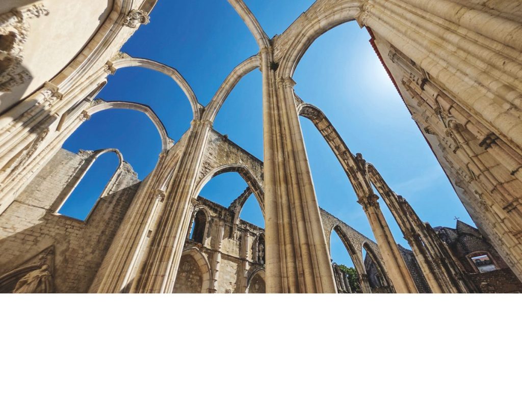
Some of Lisbon’s most well-known landmarks were affected. The Belém Tower, for example (built in 1514 on a small island in the Tagus River), found itself almost on the mainland: the earthquake radically shifted the river’s course.
survived the earthquake largely unscathed. It contains the tomb
of Vasco da Gama – one of Portugal’s most famous explorers.
While the earthquake profoundly disrupted Portugal’s future, there were some positives. The King immediately launched a rebuilding programme, replacing the city’s twisting, medieval streets with large squares and wide avenues.
The event also spawned new sciences – seismology and earthquake engineering. Scientists began to investigate how/why earthquakes and tsunamis occurred, and engineers developed a new building code. It specified flexible, wooden-framed structures that swayed rather than collapsed during earthly indigestion.
Despite these scientific advances, conspiracy theories about the cause of the earthquake inevitably gripped the devoutly Catholic country. It had arrived on a significant religious day, so obviously divine punishment for sinful behaviour!
Eventually, of course, Lisbon and Portugal recovered, but the country never really regained its economic might or leadership in the maritime sector. Still, its contribution to expanding our understanding of the planet cannot be underestimated.
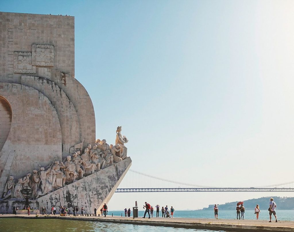
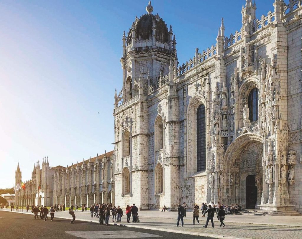
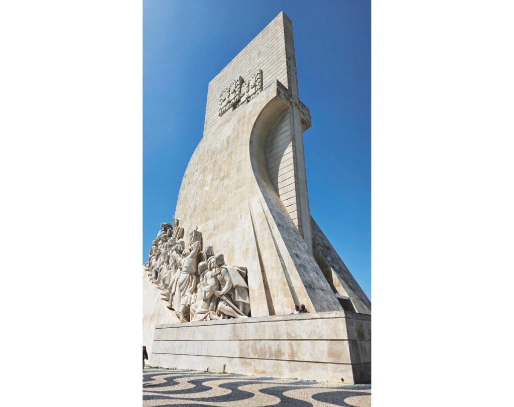
In today’s Lisbon there are numerous reminders of Portugal’s trailblazing reign. On the banks of the Tagus River is the striking Monument to the Discoveries, celebrating the country’s remarkable maritime exploits. The nearby Maritime Museum details how the Portuguese achieved those advances. It’s an excellent facility.
There are also poignant reminders of how the earthquake altered life in an instant. There’s the displaced Belém Tower, but also the ruins of the Carmo Convent (built 1423) with its gothic arches reaching to the heavens as if to ask, “Why, Lord? Why?”
Cancer and Capricorn
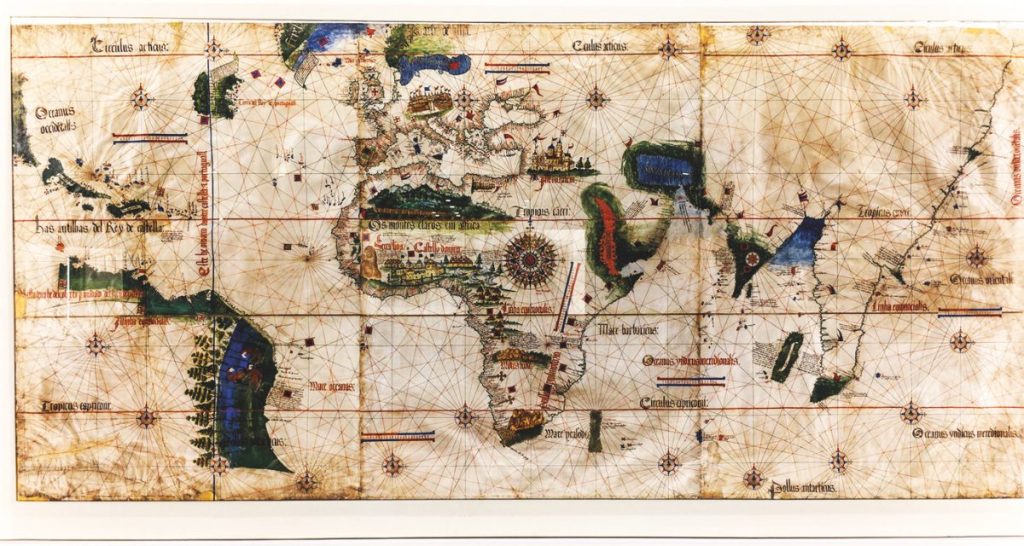
Understandably, the continents and coastlines depicted on many 15th century charts are a little fanciful, but there are usually two familiar lines of ‘latitude’ – the Tropics of Cancer and Capricorn at 23.5° North and South respectively.
The names – coined by astronomers around 2,000 years ago – were selected because of the Sun’s position relative to the constellations during the northern hemisphere solstices. At the time the Sun was in Cancer during the June solstice and in Capricorn during the December solstice.
Because of ‘precession’ (Earth’s axis of rotation wobbles over the millennia), the constellations visible at the solstices have changed. Today, during the June solstice, the Sun is in Taurus, and it is in Sagittarius during the December solstice.
Despite the wobbles, the Cancer/Capricorn labels have endured.
Columbus’ legacy
In popular culture Christopher Columbus (an Italian sailing under the Spanish flag) is often cited as the first trans-Atlantic sailor. He landed in the Bahamas in October 1492, believing it to be Asia. The more likely hero is Leif Eriksson – a Viking who arrived in today’s Newfoundland almost 500 years earlier.
Dodgy navigation aside, Columbus’ discoveries did galvanise Spanish exploration/exploitation, bringing throngs of conquistadors bent on conquering/colonising new lands and filling their ships with gold and silver.
Their exploits decimated the local populations in the Americas, not only through violence and bloodshed, but also because they brought an arsenal of ‘European’ diseases with them (smallpox, measles, and influenza).
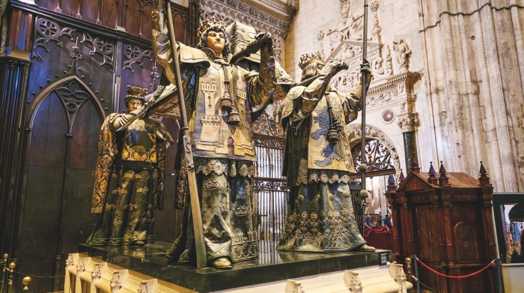
Intriguingly, Columbus’ corpse was almost as well-travelled as he was in life. He died in the Spanish city of Valladolid in 1506 but wanted to be buried on the Caribbean island of Hispaniola (today’s Haiti/Dominican Republic).
He was disinterred and buried there in 1542, disinterred again and moved to Cuba in 1795, disinterred once again in 1898, and brought to Seville. He now lies in the city’s mighty Cathedral.
Magellan’s circumnavigation
Following the discovery of the Americas, a Spanish expedition led by Portuguese skipper Ferdinand Magellan (five ships, 270 crew) set sail from Seville in 1519, seeking a westward route to the Spice Islands.
During the three-year, first-ever circumnavigation, he discovered and named the Strait of Magellan – a route into the Pacific through (rather than under) the treacherous southern tip of South America.
Overall, the expedition had mixed results. Only one ship – the Victoria – and 40 men completed the voyage. Magellan didn’t. He died in a fight with Philippine locals in 1521. Spanish navigator Juan Sebastián Elcano took over as skipper, arriving back in Seville in 1522.
Apart from proving that the planet was indeed round – and that sailing west to the Spice Islands was possible but very risky – the voyage clarified that global navigation required an International Date Line. Arriving at Cape Verde, Victoria’s crew discovered that their logbook (9 July 1522) was a day behind the local date. They eventually realised the missing day resulted from sailing west, following the Sun.
The Magellan/Elcano voyage is still regarded as one of the greatest-ever feats of seamanship, its route repeated by later voyagers. During his 1578 circumnavigation, England’s Sir Francis Drake charted the Drake Passage – a different way around the Horn. In 1960, Magellan’s route was retraced by a nuclear submarine, USS Triton. It remained submerged for the entire voyage.
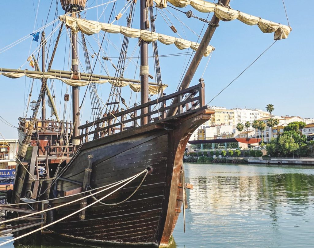
Modern replicas of the Victoria can be seen at Chile’s Nao Victoria Museum (Punta Arenas) and in Seville.


